
I am Faezur Fahim, a freelance GIS consultant specializing in policy analysis with environmental and spatial analysis expertise. With a passion for sustainability and over seven years of experience in project management, I help clients transform geospatial data into actionable solutions for addressing environmental challenges, urban planning, and disaster management.
I hold a Master’s degree in Globalization, Environment, and Social Change from Stockholm University and a Bachelor’s degree in International Relations from the Bangladesh University of Professionals. These degrees have equipped me with a deep understanding of environmental systems and stakeholder engagement. I’ve also earned professional certifications in Programme and Project Management (University of Birmingham) and Certified Supervisor (ICPM-James Madison University), reflecting my dedication to professional excellence.
I am proficient in GIS tools, including QGIS and ArcGIS, as well as 3D imaging software such as Pix4D. Additionally, I have experience designing community-level standalone water pump systems that utilize solar panels.
Using ArcGIS, I perform regional hydrological modeling, early wildfire detection, and environmental spatial analysis, delivering actionable insights for sustainable planning and disaster preparedness. Through Pix4D, I generate detailed 3D models of urban areas, supporting applications in urban development, infrastructure planning, and environmental impact assessments.
My skill set also includes drone-based surveys and remote sensing, enabling the collection of precise data for a wide range of projects.
I am passionate about leveraging satellite images and human-centered policies to address environmental issues and improve spatial planning. Growing up in an area affected by environmental devastation, I believe satellite imagery can save lives through early prediction systems. As a policy enthusiast, I see the value of drone images and satellite photos in organizing a city swirl. I’m committed to supporting projects focused on sustainability, offering huge rabat for initiatives in environmentally degraded areas on a bigger scale of social impacts. My goal is to create impactful, data-driven outcomes that enhance human life.
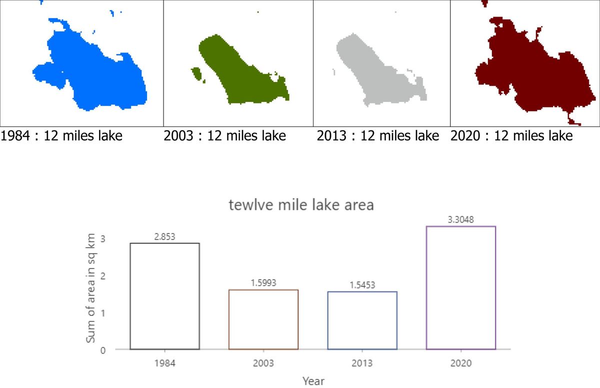
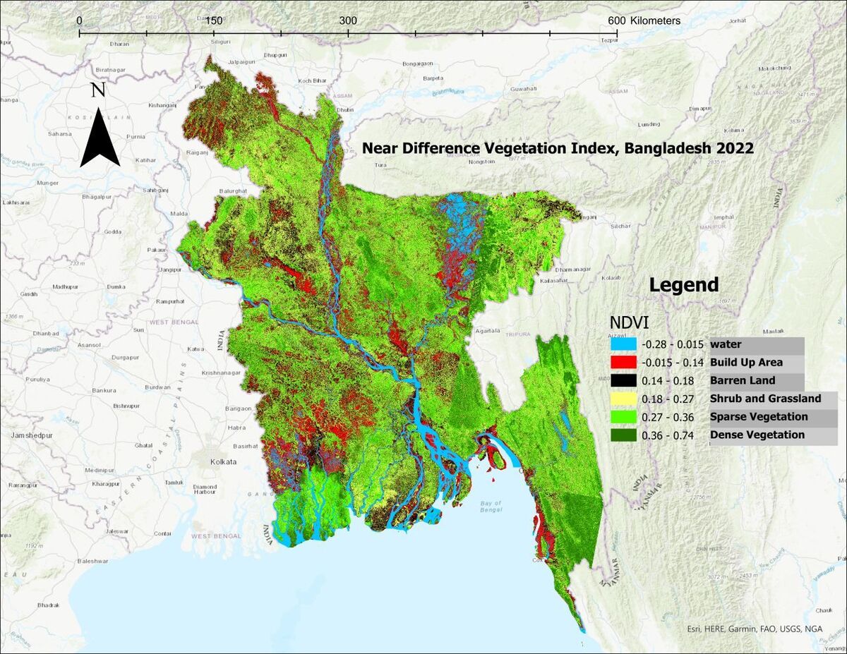
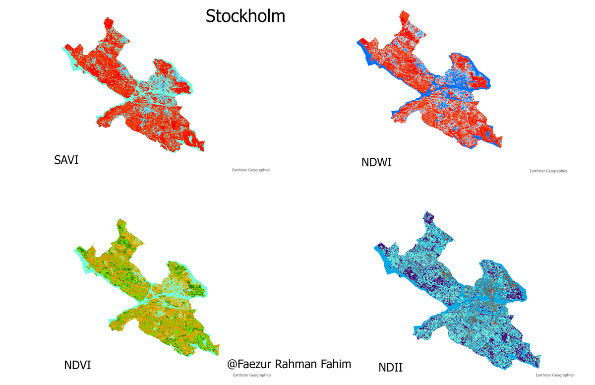
I use satellite imagery and GIS tools to monitor environmental changes, such as deforestation, urban expansion, or coastal erosion. This includes creating vegetation index maps (e.g., NDVI, NDII, SAVI, NDWI, MNDWI, NDMI, NDSI, BSI, MNDBI, BAEI,), analyzing lake shrinkage, or mapping wildfire risks.
I analyze geographic data to support urban development, such as mapping population density, assessing accessibility to services, or optimizing land use for zoning plans.
I model water flow and predict flood risks using GIS tools, helping clients prepare for climate-related challenges like heavy rainfall or rising sea levels.
I use drones to conduct aerial surveys, producing high-resolution 3D models and orthomosaics for construction sites, farms, or environmental studies.
I design solar energy systems using GIS and PVsyst, identifying the best locations for panels and estimating energy output for homes, businesses, or communities.

@Faezur Rahman Fahim is solo trader in Sweden. Approved for FA tax. Vat registration number: 980503683801